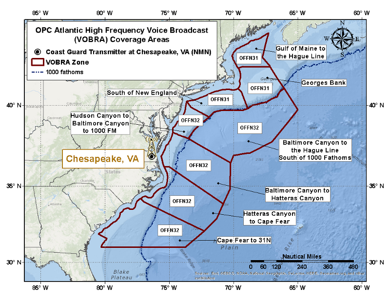
OPC Atlantic Voice Broadcast (VOBRA) Offshore Waters Forecast Areas
X
Gulf of Maine to the Hague Line
Updated: 451 AM EDT Mon Mar 31 2025

.TODAY...S to SW winds 20 to 30 kt. Seas 6 to 11 ft. Chance of
rain. Areas of fog. Vsby 1 NM or less.
.TONIGHT...SW winds 20 to 30 kt. Seas 6 to 11 ft. Scattered
showers and chance of tstms with vsby 1 nm or less.
.TUE...N to NW winds 15 to 25 kt. Seas 6 to 10 ft. Chance of
showers with vsby 1 nm or less.
.TUE NIGHT...NW winds 15 to 25 kt, becoming N. Seas 5 to 9 ft.
.WED...N winds 10 to 20 kt, becoming N to NW less than 10 kt.
Seas 5 to 8 ft.
.WED NIGHT...S winds 5 to 15 kt, increasing to 10 to 20 kt. Seas
3 to 6 ft.
.THU...S to SW winds 20 to 30 kt. Seas 6 to 10 ft.
.THU NIGHT...W to SW winds 15 to 25 kt. Seas 6 to 10 ft.
.FRI...W to NW winds 5 to 15 kt. Seas 4 to 7 ft.
.FRI NIGHT...N to NW winds 10 to 20 kt. Seas 3 to 5 ft.
X
Georges Bank from the Northeast Channel to the Great South Channel, including waters east of Cape Cod to the Hague Line
Updated: 451 AM EDT Mon Mar 31 2025

.TODAY...S to SW winds 20 to 30 kt. Seas 6 to 10 ft. Chance of
rain early. Areas of fog. Vsby 1 NM or less.
.TONIGHT...S winds 20 to 30 kt. Seas 7 to 12 ft. Scattered
showers and chance of tstms with vsby 1 nm or less.
.TUE...S to SW winds 20 to 30 kt, becoming N 10 to 20 kt. Seas
8 to 13 ft. Scattered showers with vsby 1 nm or less.
.TUE NIGHT...N to NW winds 15 to 25 kt. Seas 6 to 10 ft.
.WED...N winds 10 to 20 kt, becoming N to NE less than 10 kt.
Seas 5 to 9 ft.
.WED NIGHT...E to SE winds 5 to 15 kt, becoming S to SE 10 to
20 kt. Seas 3 to 6 ft.
.THU...S to SE winds 15 to 25 kt, becoming S to SW 20 to 30 kt.
Seas 3 to 6 ft, building to 6 to 10 ft.
.THU NIGHT...W to SW winds 15 to 25 kt. Seas 6 to 10 ft.
.FRI...W winds 10 to 20 kt, becoming W to NW 5 to 15 kt. Seas
4 to 8 ft.
.FRI NIGHT...NW winds 5 to 15 kt, becoming N 10 to 20 kt. Seas
3 to 6 ft.
X
South of New England from the Great South Channel to Hudson Canyon, including the waters south of Marthas Vineyard and Nantucket Island out to 1000 fm
Updated: 451 AM EDT Mon Mar 31 2025

.TODAY...S to SW winds 20 to 25 kt. Seas 6 to 10 ft. Areas of
fog. Scattered showers and tstms. Vsby 1 NM or less.
.TONIGHT...S to SW winds 20 to 30 kt. Seas 6 to 11 ft. Scattered
showers and tstms with vsby 1 nm or less.
.TUE...N to NW winds 15 to 25 kt. Seas 6 to 11 ft. Chance of
showers with vsby 1 nm or less.
.TUE NIGHT...N to NW winds 10 to 20 kt. Seas 4 to 8 ft.
.WED...NE winds 10 to 20 kt, becoming E 5 to 15 kt. Seas 4 to
7 ft.
.WED NIGHT...SE winds 10 to 20 kt. Seas 4 to 6 ft.
.THU...S to SW winds 15 to 25 kt. Seas 4 to 8 ft.
.THU NIGHT...SW winds 15 to 25 kt. Seas 5 to 8 ft.
.FRI...W to SW winds 10 to 20 kt, becoming W to NW 5 to 15 kt.
Seas 4 to 8 ft.
.FRI NIGHT...NW winds 10 to 20 kt, becoming N. Seas 4 to 6 ft.
X
Hudson Canyon to Baltimore Canyon including the waters west of 39.3N 71.9W...SW to 37.7N 72.9W
Updated: 459 AM EDT Mon Mar 31 2025

.TODAY...S winds 20 to 25 kt. Seas 5 to 9 ft. Areas of fog.
Scattered showers and tstms. Vsby 1 NM or less.
.TONIGHT...S winds 15 to 25 kt, becoming W to SW. Seas 5 to
9 ft. Scattered showers and tstms with vsby 1 nm or less.
.TUE...NW winds 15 to 25 kt. Seas 4 to 8 ft. Scattered showers.
.TUE NIGHT...N to NW winds 5 to 15 kt, becoming N to NE. Seas
4 to 7 ft.
.WED...E to NE winds 10 to 20 kt, becoming E to SE 10 to 15 kt.
Seas 4 to 6 ft.
.WED NIGHT...SE winds 10 to 20 kt, becoming S 15 to 20 kt. Seas
4 to 6 ft.
.THU...S to SW winds 20 to 25 kt. Seas 5 to 7 ft.
.THU NIGHT...SW winds 15 to 25 kt. Seas 5 to 8 ft.
.FRI...W to SW winds 15 to 25 kt. Seas 4 to 8 ft.
.FRI NIGHT...N winds 5 to 15 kt, increasing to 10 to 20 kt. Seas
3 to 6 ft.
X
Baltimore Canyon to the Hague Line south of 1000 fm
Updated: 459 AM EDT Mon Mar 31 2025

...GALE WARNING...

.TODAY...SW winds 15 to 25 kt, becoming S 20 to 30 kt, then,
increasing to 25 to 35 kt. Seas 8 to 13 ft.
.TONIGHT...S winds 30 to 40 kt. Seas 9 to 16 ft. Scattered
showers and tstms with vsby 1 nm or less.
.TUE...SW winds 30 to 40 kt, becoming W to SW 20 to 30 kt. Seas
10 to 17 ft. Scattered showers and tstms with vsby 1 nm or less.
.TUE NIGHT...N winds 15 to 25 kt. Seas 7 to 12 ft.
.WED...N to NE winds 10 to 20 kt, becoming E to NE. Seas 6 to
10 ft.
.WED NIGHT...E to SE winds 10 to 20 kt, becoming S to SE. Seas
4 to 8 ft.
.THU...S winds 15 to 25 kt. Seas 4 to 7 ft.
.THU NIGHT...SW winds 15 to 25 kt. Seas 5 to 9 ft.
.FRI...W to SW winds 15 to 25 kt. Seas 6 to 9 ft.
.FRI NIGHT...W to NW winds 10 to 20 kt, becoming N. Seas 5 to
8 ft.
X
Baltimore Canyon to Hatteras Canyon out to 36N 70W to 34N 71W
Updated: 459 AM EDT Mon Mar 31 2025

...GALE WARNING...

.TODAY...S winds 20 to 30 kt, increasing to 25 to 35 kt. Seas
8 to 13 ft. Scattered showers and tstms with vsby 1 nm or less.
.TONIGHT...S winds 25 to 35 kt, becoming SW. Seas 9 to 15 ft.
Numerous showers and scattered tstms with vsby 1 nm or less.
.TUE...SW winds 20 to 30 kt, becoming NW 10 to 20 kt. Seas 7 to
13 ft. Scattered showers and tstms.
.TUE NIGHT...N winds 10 to 20 kt, becoming N to NE 5 to 15 kt.
Seas 5 to 9 ft.
.WED...E to NE winds 5 to 15 kt. Seas 4 to 7 ft.
.WED NIGHT...SE winds 10 to 20 kt, becoming S. Seas 4 to 8 ft.
.THU...S winds 15 to 25 kt. Seas 4 to 8 ft.
.THU NIGHT...S to SW winds 15 to 25 kt. Seas 5 to 9 ft.
.FRI...SW winds 15 to 25 kt. Seas 6 to 10 ft.
.FRI NIGHT...W winds 10 to 20 kt. Seas 4 to 8 ft.
X
Hatteras Canyon to Cape Fear out to 34N 71W to 32N 73W
Updated: 459 AM EDT Mon Mar 31 2025

...GALE WARNING...

.TODAY...S winds 20 to 30 kt. Seas 7 to 12 ft. Numerous showers
and scattered tstms with vsby 1 nm or less.
.TONIGHT...S to SW winds 25 to 35 kt. Seas 7 to 12 ft. Numerous
showers and scattered tstms with vsby 1 nm or less.
.TUE...W to SW winds 20 to 30 kt, becoming N 10 to 20 kt. Seas
7 to 12 ft. Scattered showers and tstms.
.TUE NIGHT...N to NE winds 10 to 20 kt, becoming NE 10 to 15 kt.
Seas 5 to 9 ft. Chance of showers and tstms.
.WED...E winds 10 to 15 kt. Seas 4 to 7 ft.
.WED NIGHT...S to SE winds 10 to 20 kt. Seas 4 to 7 ft.
.THU...S to SW winds 15 to 25 kt. Seas 4 to 7 ft.
.THU NIGHT...S to SW winds 15 to 25 kt. Seas 4 to 8 ft.
.FRI...SW winds 15 to 25 kt. Seas 4 to 8 ft.
.FRI NIGHT...W to SW winds 15 to 25 kt. Seas 4 to 7 ft.
X
Cape Fear to 31N out to 32N 73W to 31N 74W
Updated: 459 AM EDT Mon Mar 31 2025

...GALE WARNING...

.TODAY...S to SW winds 20 to 30 kt. Seas 6 to 11 ft. Numerous
showers and scattered tstms with vsby 1 nm or less.
.TONIGHT...SW winds 20 to 30 kt, increasing to 25 to 35 kt. Seas
7 to 12 ft. Scattered showers and tstms with vsby 1 nm or less.
.TUE...W to SW winds 15 to 25 kt. Seas 6 to 10 ft. Scattered
showers and tstms.
.TUE NIGHT...E to NE winds 5 to 15 kt, becoming E 10 to 20 kt.
Seas 4 to 7 ft. Chance of showers and tstms.
.WED...E to SE winds 10 to 20 kt. Seas 4 to 7 ft.
.WED NIGHT...S to SE winds 15 to 25 kt. Seas 4 to 7 ft.
.THU...S winds 10 to 20 kt. Seas 4 to 7 ft.
.THU NIGHT...S winds 10 to 20 kt. Seas 4 to 6 ft.
.FRI...S to SW winds 10 to 20 kt. Seas 4 to 6 ft.
.FRI NIGHT...SW winds 10 to 20 kt, diminishing to 5 to 15 kt.
Seas 3 to 5 ft.
- Below is a map of the Array Voice Broadcast (VOBRA) Offshore Waters Forecast. Clicking on a zone will display the forecast for that area.