
| Hurricane Warnings in Effect | Pacific: High Seas EP1 and EPI |
Wind Against Current Product Description
Contents
Part I - Mission ConnectionPart II - Technical
1. Product Description
The NWS is responsible for making weather, water and climate information widely available to the public using commonly accepted standards and technologies. Wind over the ocean is a critical parameter to a wide range of marine operations and activities. Wind can reach destructive force in a variety of storms and through momentum exchange, force wave development. The WMO considers wind at sea to be significant enough to require warnings for conditions of Beaufort Force 8 and greater WMO Manual for Marine Meteorological Services Volume I.
The western North Atlantic is a very challenging area both meteorologically and oceanographically. The western boundary current of the North Atlantic consists of the Florida Current (from the Straits of Florida to off of Cape Hatteras) and Gulf Stream (from off of Cape Hatteras to south of Newfoundland). The waters off the east coast of the United States contain some of the highest temperature contrasts in the world with the warm waters of the Gulf Stream system (Florida Current and Gulf Stream) moving northeastwards from off the North Carolina coast abutting the cold waters of the Labrador Current flowing southwestward just north and northwest of the Gulf Stream. These waters are where many North Atlantic winter ocean storms are born, where thunderstorms erupt, and where wind waves and swell can interact with the strong current of the Gulf Stream system and produce short period, very high breaking waves.
To highlight the potential for strong winds to oppose the strong current of the Gulf Stream system, the Ocean Prediction Center developed an Experimental Wind Against Current Product. This product uses the 10m vector winds from the NWS Global Forecast System (GFS) atmospheric model and the ocean surface current from the U.S. Navy Coastal Ocean Model (NCOM) to highlight areas and strength of the wind opposing ocean currents.
2. Purpose/Intended Use
The purpose of this product is to the enhance awareness for mariners of the development of potentially dangerous conditions over the waters of the Florida Current and Gulf Stream when strong winds blow opposite the moderate to strong current of the Gulf Stream system.
3. Audience
These products are intended for mariners operating over the western North Atlantic ocean to enhance awareness of potentially dangerous conditions when strong winds blow opposite the currents of the Gulf Stream system.
4. Presentation
Experimental graphical display is available on the OPC web page at:
http://www.opc.ncep.noaa.gov/Loops/WindCurrent_ncomhires_00Z/index.php
5. Feedback Method
We are always seeking to improve the availability and quality of NWS products and services based on user feedback. Comments regarding the
Experimental Wind Against Current Product may be submitted via a short survey:
http://www.nws.noaa.gov/survey/nws-survey.php?code=EGWAC or via
email to Joseph Sienkiewicz at the National Weather Service Ocean Prediction Center, Chief of Ocean Applications:
Contact via Email.
The feedback period for this experimental product will extend through June 30, 2016.
6. Format and Science Basis
The Experimental Wind Against Current Product is derived from the 10m winds from the NWS Global Forecast System (GFS) model and ocean surface current from the U.S. Navy high resolution Navy Coastal Ocean Model (NCOM) available from the Ocean Prediction Center at:
http://www.opc.ncep.noaa.gov/newNCOM/NCOM_GulfStream_currents_java.shtml
The graphical product displays 24 hour composites of the maximum wind speed component directed opposite the current vector of 0.5 knots or greater. The magnitude of the wind vector opposing the ocean current is calculated by obtaining the negative value of the dot product of the two vectors (wind and current) and normalizing by dividing by the current magnitude. The value displayed is the maximum over a 24 hour period and is valid for the period ending at the time in the label below the graphical image. Therefore, there is no adjustment for stronger current, only the strength of the wind blowing opposite the current vector is shown. The time composite is done to address any error in timing of the wind field.
- Parameters
24 hour maximum wind component in opposition to the underlying ocean surface current vector.
- Resolution
Graphical output is displayed at a 1/3 of a degree of latitude resolution.
- Data collection
The reference time is the time of the most recent NCOM model. The data is available once a day based on the 0000 UTC runs of the GFS and NCOM models
- Horizontal and Temporal Resolution
The Wind Against Current product is displayed on a 1/3 degree resolution image for the western North Atlantic from the Bahamas to the New England coast from 65 degrees West Longitude to the U.S. coast. Sampling period ranges from approximately 45 to 50 minutes for each grid file.
- Domain
The graphical products cover the western North Atlantic and are displayed on a Mercator projection.
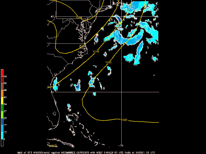
Figure 1. Image of Wind Against Current 24 hour maximum wind composite valid for the period ending 1500 UTC 1 May 2014. Base time of the GFS and NCOM were 0000 UTC 30 April 2014.
7. Availability
These products will be available 24 hours a day and 7 days a week and updated once per day at approximately 1200 UTC.
 Facebook
 X
X