


| Hurricane Warnings in Effect | Pacific: High Seas EP1 and EPI |
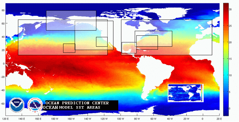
Ocean Model SST Areas
The NCEP Global Real-Time Ocean Forecast System (RTOFS-Global) data is based on the U.S. Navy implementation of Global HYCOM.
Regional NCOM data is provided by the Naval Oceanographic Office (NAVO).
(Mouseover and click the desired area to view the valid Global Ocean Model SST 0-72 hour forecast data)
***Attention*** NCOM Regional files with surface temperature and currents are available in GRIB2 format. See links below.
For NCOM GRIB2 files with surface temperature and currents: http://ftp.opc.ncep.noaa.gov/grids/operational/NCOM/regional/GRIB2/
For Regional NCOM Data: http://ftp.opc.ncep.noaa.gov/grids/operational/NCOM/regional/
For archived NCOM Data: http://www.ncddc.noaa.gov/ocean-nomads/global-ncom/
For Data via Nomads GDS server: http://nomads.ncep.noaa.gov:9090/dods/ncom
For East Coast images: NCOM High Resolution Oceanic Model: Gulf Stream
For Global RTOFS Data: http://ftp.opc.ncep.noaa.gov/grids/operational/GLOBALHYCOM/
For RTOFS Global Data via the NCEP operational NOMADS server: http://nomads.ncep.noaa.gov:9090/
G-RTOFS Model Information
The Global Real-Time Ocean Forecast System is based on NAVO's configuration of the 1/12 deg. eddy resolving global HYCOM model and is initialized daily with NAVO generated initial conditions using the NCODA system. G-RTOFS is forced with NCEP's operational GFS winds. For more details see: NOAA/NCEP/MMAB GRTOFS Web Page
Regional NCOM Model Information
The Regional NCOM models have a resolution of 1/36 deg. (3 km). The U.S. Navy Operational Global Ocean Model (NCOM), developed by the Naval Research Laboratory (Barron et al, 1&2) and maintained by the Naval Oceanographic Office, provides boundary conditions for the regional models. The regional NCOM models found here include the U.S. East Coast (ncom_useast), The Southern California Coast (ncom_socal), Hawaii Coasts (ncom_relo_hawaii) and the Gulf of America and Caribaean Seas (ncom_relo_amseas). The Navy Coupled Ocean Data Assimilation System (NCODA) provides the data assimilation for NCOM including SSH, SST, and in situ observations. For more information about NCOM see:
NCOM Publications and Validation Test Report
References
1. Barron, C.N., A.B. Kara, H.E. Hurlburt, C. Rowley, and L.F. Smedstad, 2004: Sea surface height predictions from the Global Navy Coastal Ocean Model (NCOM) during 1998-2001. J. Atmos. Oceanic Technol., 21(12), 1876-1894.
2. Barron, C.N., A.B. Kara, P.J. Martin, R.C. Rhodes, and L.F. Smedstad, 2006: Formulation, implementation and examination of vertical coordinate choices in the global Navy Coastal Ocean Model (NCOM). Ocean Modeling, 11, 347-375, doi:10.1016/j.ocemod.2005.01.004.