


| Hurricane Warnings in Effect | Pacific: High Seas EP1 and EPI |
Experimental Gridded Wind Vectors from Satellite Scatterometers
Important Notice:
The GRIB2 Product Definition Templates (PDT) for this data are incomplete. The templates will be changing when table updates are completed.
For the U and V components of the wind parameters and the quality control (QC) parameter, a new Product Definition Template (PDT) for satellite products which allows the inclusion of quality control in the U and V grids is needed. Changes are being proposed to update the PDT with version 4.35, Satellite Product with Statistical Processing. It's similar to PDT 4.31 (Satellite Product) but includes an additional octet for QC. The number of contributing spectral bands (NB) for ASCAT (PDT 4.31) also needs to be determined.
A new Discipline 3 parameter, in a new Miscellaneous category, for the TSEC parameter needed for ASCAT (seconds prior to initial reference time) is also being proposed.
Part 1 – Mission Connection
1. Product Description:
The NWS is responsible for making weather, water and climate information widely available to the public using commonly accepted standards and
technologies. Wind over the ocean is a critical parameter to a wide range of marine operations and activities. Wind can reach destructive
force in a variety of storms and through momentum exchange, force wave development. The WMO considers wind at sea to be significant enough
to require warnings for conditions of Beaufort Force 8 and greater .
Observations of wind direction and speed over the global ocean are very sparse as compared to similar observations over populated land areas.
Volunteer Observing Ships (VOS), oil exploration and recovery platforms, island sources, and fixed buoys provide a sparse network of observations.
Satellite radars called scatterometers measure the roughness of the ocean surface and through multiple observations of a given area are able
to give an estimate of the wind speed and direction.
The Experimental Gridded Wind Vectors from Satellite Scatterometers is in gridded form (GRIB2). The Ocean Prediction Center (OPC) produces
two products based on data from the EUMETSAT Advanced SCATterometer (ASCAT) on the operational European MetOp A and B satellites, ASCAT-A and B, respectively.
2. Purpose/Intended Use:
The purpose of this product is to enhance awareness of wind direction and speed conditions over the data sparse global ocean. Mid and high-latitude
storms, tropical cyclones, and coastal orography produce hazardous wind conditions that threaten the safety of mariners at sea. Wind powered vessels
require foreknowledge of rapid wind shifts, areas of very weak winds such as under areas of high pressure and the doldrums and winds of an adverse direction.
3. Audience:
These products are intended for mariners operating over the open global and Arctic oceans to enhance awareness and supplement the sparse conventional
observations. Mariners are using broadband capabilities as a means of communication and to obtain the latest weather information. Commercial and open
source software that are able to request, subset, download, and display meteorological and oceanographic fields in Gridded Binary (GRIB) form have
been used by mariners for over twenty years. GRIB files are used across the full range of vessels and operations.
4. Presentation:
Experimental gridded fields in GRIB2 format are available on the OPC web page for the global ocean between 67 north and south latitude and for the
Arctic north of 67degrees north latitude at:
ftp://ftp.opc.ncep.noaa.gov/data/ascat_ab/ -or- http://ftp.opc.ncep.noaa.gov/data/ascat_ab/
ftp://ftp.opc.ncep.noaa.gov/data/ascat_ab_67n/ -or- http://ftp.opc.ncep.noaa.gov/data/ascat_ab_67n/
Once downloaded a software program that can decode and display GRIB2 data will be needed to display the product. An example program is
NCEP's Degrib (also called the NDFD GRIB2 Decoder).
5. Feedback Method:
We are always seeking to improve the availability and quality of NWS products and services based on user feedback. Comments regarding the experimental
Gridded Wind Vectors from Satellite Scatterometers Product may be submitted via a short survey:
http://www.nws.noaa.gov/survey/nws-survey.php?code=GWVSS
or
via email the National Weather Service Ocean Prediction Center, Chief of Ocean Applications at
Email Feedback Page.
The feedback period for this experimental product will extend through April 30, 2015.
Part 2 – Technical
1. Format and Science BasisThe Experimental Gridded Wind Vector Products from Satellite Scatterometers are derived from wind retrievals from the European (EUMETSAT) ASCAT-A sand B instruments on MetOp A and B. The following link to EUMETSAT gives detailed technical information concerning the ASCAT instruments, ASCAT technical description.
Gridded files are generated hourly in GRIB2 format by the Ocean Prediction Center on the NCEP Compute Farm server system. Once generated the experimental product will be transferred to the NCEP RZDM ftp site for availability and then made available via a link from the NWS Ocean Prediction Center website. Graphical images will be generated every 15 minutes using the GEMPAK software and uploaded to the web as soon as generated in gif format.
a. Parameters
1. U component of wind (ms-1)
2. V component of wind ((ms-1)
3. KNMI Quality Control Indicator (passed=2 / failed=1)
4. Seconds Prior to the Data Collection Time (s)
b. Resolution
1. ASCAT gridded product is interpolated to 1/4 degree
c. Data collection (reference time) is the time of the most recent ASCAT observation in the swath sensed by the instrument. The time of an observation is equal to the Data Collection Time or the number of seconds prior to the Data Collection Time.
d. KNMI Quality Control Indicator is described fully in http://projects.knmi.nl/publications/fulltexts/quikscat_final_report_eumetsat.pdf
e. Horizontal and Temporal Resolution
The ASCAT product is written to an 28 x 28 km grid (1/4 degree). Sampling period ranges from approximately 45 to 50 minutes for each grid file.
f. Domains
The gridded products are generated in two domains. The near global product extends from 67 degrees North Latitude to 67 degrees South Latitude and is mapped to a Cylindrical Equidistant Projection (CED). The Arctic domain covers the open waters north of 67 degrees North Latitude.
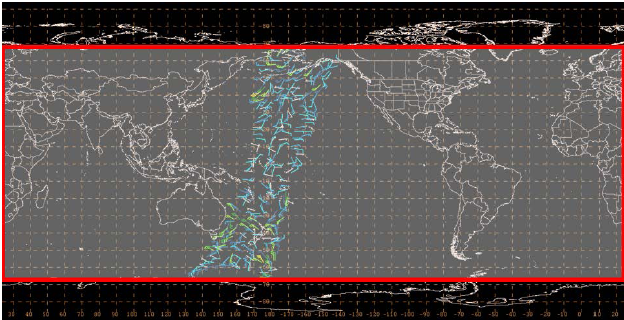
Figure 1. Domain of Global experimental scatterometer based gridded wind field in gray and outlined in red.
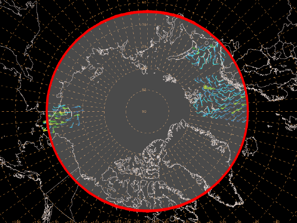
Figure 2. ASCAT gridded vector wind product domain for open waters north of 67 degrees North Latitude.
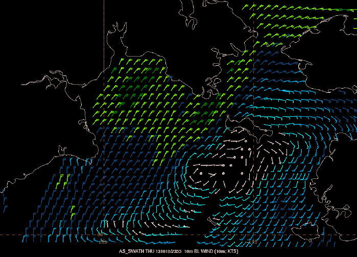
Figure 3. ASCAT gridded product showing color coded winds over the Bering Sea.
2. Availability
These products will be available 24 hours a day and 7 days a week.