| Hurricane Warnings in Effect | Pacific: High Seas EP1 and EPI |
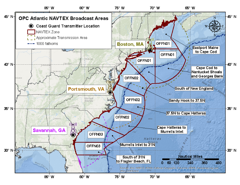
OPC Atlantic NAVTEX Offshore Waters Forecast Areas
X
Eastport Maine to Cape Cod
Updated: 440 AM EDT Tue Jul 28 2026

.TODAY...S winds 5 to 15 kt. Seas 3 to 4 ft.
.TONIGHT...SE winds 10 to 20 kt. Seas 3 to 4 ft.
.WED...E winds 10 to 20 kt. Seas 3 to 6 ft. Chance of rain.
.WED NIGHT...E winds 10 to 20 kt. Seas 4 to 6 ft. Rain.
.THU...E to NE winds 10 to 20 kt. Seas 5 to 7 ft.
.THU NIGHT...NE winds 10 to 20 kt. Seas 5 to 7 ft.
.FRI...NE winds 10 to 20 kt. Seas 4 to 6 ft.
.FRI NIGHT...N winds less than 10 kt. Seas 3 to 5 ft.
.SAT...Variable winds less than 10 kt. Seas 3 to 5 ft.
.SAT NIGHT...SW winds less than 10 kt. Seas 3 to 4 ft.
X
Cape Cod to Nantucket Shoals and Georges Bank
Updated: 440 AM EDT Tue Jul 28 2026

.TODAY...S to SE winds 5 to 15 kt. Seas 3 to 5 ft.
.TONIGHT...SE winds 10 to 20 kt. Seas 3 to 5 ft.
.WED...S to SE winds 15 to 25 kt. Seas 4 to 7 ft. Rain.
.WED NIGHT...E to SE winds 10 to 20 kt. Seas 4 to 7 ft. Rain.
.THU...W winds 10 to 20 kt. Seas 5 to 9 ft.
.THU NIGHT...W winds 10 to 20 kt. Seas 5 to 8 ft.
.FRI...W to NW winds 5 to 15 kt. Seas 4 to 8 ft.
.FRI NIGHT...NW winds 5 to 15 kt. Seas 3 to 6 ft.
.SAT...Variable winds less than 10 kt. Seas 3 to 5 ft.
.SAT NIGHT...Variable winds less than 5 kt. Seas 3 to 5 ft.
X
South of New England
Updated: 440 AM EDT Tue Jul 28 2026

.TODAY...S winds 10 to 20 kt. Seas 3 to 5 ft. Slight chance of
rain.
.TONIGHT...S to SE winds 15 to 25 kt. Seas 4 to 6 ft. Rain.
.WED...S to SE winds 15 to 25 kt. Seas 5 to 7 ft. Chance of
rain.
.WED NIGHT...W winds 5 to 15 kt. Seas 4 to 7 ft. Chance of rain.
.THU...W to NW winds 10 to 20 kt. Seas 4 to 6 ft.
.THU NIGHT...N to NW winds 5 to 15 kt. Seas 4 to 7 ft.
.FRI...N to NW winds 5 to 15 kt. Seas 3 to 6 ft.
.FRI NIGHT...NW winds less than 10 kt. Seas 3 to 5 ft.
.SAT...S winds less than 10 kt. Seas 3 to 4 ft.
.SAT NIGHT...S to SW winds less than 10 kt. Seas 3 to 4 ft.
X
Sandy Hook to 37.5N
Updated: 441 AM EDT Tue Jul 28 2026

.TODAY...S winds 10 to 20 kt. Seas 3 to 5 ft.
.TONIGHT...S winds 15 to 25 kt. Seas 4 to 7 ft. Rain.
.WED...W to SW winds 15 to 25 kt. Seas 5 to 7 ft. Isolated
tstms.
.WED NIGHT...W winds 5 to 15 kt. Seas 4 to 6 ft.
.THU...W to NW winds 10 to 20 kt. Seas 4 to 6 ft.
.THU NIGHT...NW winds 5 to 15 kt. Seas 3 to 6 ft.
.FRI...Variable winds 5 to 15 kt. Seas 3 to 5 ft.
.FRI NIGHT...Variable winds less than 10 kt. Seas 3 to 5 ft.
.SAT...S to SE winds less than 10 kt. Seas 3 to 5 ft.
.SAT NIGHT...S winds less than 10 kt. Seas 3 to 4 ft.
X
37.5N to Cape Hatteras
Updated: 441 AM EDT Tue Jul 28 2026

.TODAY...S winds 10 to 20 kt. Seas 3 to 4 ft.
.TONIGHT...SW winds 15 to 25 kt. Seas 4 to 7 ft. Isolated tstms.
.WED...W to SW winds 15 to 25 kt. Seas 5 to 7 ft. Isolated
tstms.
.WED NIGHT...W winds 10 to 20 kt. Seas 5 to 7 ft. Isolated
tstms.
.THU...W to NW winds 5 to 15 kt. Seas 4 to 7 ft.
.THU NIGHT...W to SW winds 5 to 15 kt. Seas 4 to 7 ft.
.FRI...N to NW winds less than 10 kt. Seas 3 to 6 ft.
.FRI NIGHT...Variable winds less than 10 kt. Seas 3 to 6 ft.
.SAT...S to SE winds 5 to 15 kt. Seas 3 to 5 ft.
.SAT NIGHT...S winds 15 to 25 kt. Seas 4 to 7 ft.
X
Cape Hatteras to Murrells Inlet
Updated: 441 AM EDT Tue Jul 28 2026

.TODAY...SW winds 10 to 20 kt. Seas 3 to 4 ft.
.TONIGHT...SW winds 15 to 25 kt. Seas 5 to 7 ft. Isolated tstms.
.WED...W to SW winds 15 to 25 kt. Seas 5 to 8 ft. Isolated
tstms.
.WED NIGHT...W to SW winds 10 to 20 kt. Seas 5 to 8 ft. Isolated
tstms.
.THU...SW winds 10 to 20 kt. Seas 5 to 7 ft.
.THU NIGHT...W to SW winds 10 to 20 kt. Seas 5 to 7 ft.
.FRI...Variable winds 5 to 15 kt. Seas 4 to 7 ft.
.FRI NIGHT...Variable winds 5 to 15 kt. Seas 4 to 6 ft.
.SAT...S to SW winds 10 to 20 kt. Seas 3 to 5 ft.
.SAT NIGHT...S winds 15 to 25 kt. Seas 5 to 8 ft.
X
Murrells Inlet to 31N
Updated: 444 AM EDT Tue Jul 28 2026

.TODAY...S to SW winds 10 to 20 kt. Seas 3 to 4 ft. Isolated
tstms.
.TONIGHT...SW winds 15 to 25 kt. Seas 4 to 7 ft. Isolated tstms.
.WED...W to SW winds 15 to 25 kt. Seas 5 to 8 ft. Isolated
tstms.
.WED NIGHT...W to SW winds 15 to 25 kt. Seas 5 to 7 ft. Isolated
tstms.
.THU...W to SW winds 15 to 25 kt. Seas 4 to 7 ft.
.THU NIGHT...W to SW winds 10 to 20 kt. Seas 4 to 7 ft.
.FRI...S to SW winds 5 to 15 kt. Seas 3 to 6 ft.
.FRI NIGHT...S winds 5 to 15 kt. Seas 3 to 5 ft.
.SAT...S to SW winds 10 to 20 kt. Seas 4 to 7 ft.
.SAT NIGHT...S to SW winds 15 to 25 kt. Seas 5 to 8 ft.
X
South of 31N
Updated: 444 AM EDT Tue Jul 28 2026

.TODAY...S to SW winds 5 to 15 kt. Seas 3 to 4 ft. Isolated
tstms.
.TONIGHT...SW winds 10 to 20 kt. Seas 3 to 5 ft. Isolated tstms.
.WED...SW winds 10 to 20 kt. Seas 4 to 7 ft. Isolated tstms.
.WED NIGHT...W to SW winds 10 to 20 kt. Seas 5 to 8 ft. Isolated
tstms.
.THU...SW winds 10 to 20 kt. Seas 5 to 7 ft.
.THU NIGHT...W to SW winds 10 to 20 kt. Seas 5 to 7 ft.
.FRI...SW winds 5 to 15 kt. Seas 4 to 6 ft.
.FRI NIGHT...SW winds 5 to 15 kt. Seas 4 to 6 ft.
.SAT...SW winds 10 to 20 kt. Seas 4 to 7 ft.
.SAT NIGHT...SW winds 10 to 20 kt. Seas 5 to 7 ft.
- Below is a map of the Atlantic NAVTEX Offshore Waters Forecast areas. Clicking on a zone will display the forecast for that area.