


| Hurricane Warnings in Effect | Pacific: High Seas EP1 and EPI |
GWES Probabilistic Wave Height Guidance Explanation
Global Wave Ensemble System
The Global ocean Wave Ensemble forecast System (GWES) provides wave forecasts from 21 wave models run simultaneously using winds from NCEP's Global Forecast System GFS (control member) and from the Global Ensemble Forecast System GEFS (20 perturbed members). The GWES is run 4 times daily based on 0000, 0600, 1200, and 1800 UTC start time and provides predictions to 240 hours. That's 84 separate ensemble members per day. For detailed information concerning the GWES please see NCEP Environmental Modling Centers's Glocal Ensemble Ocean Wave Forecast System.Available plots
Four different types of plots are available for display for three domains, Atlantic, Pacific, and Alaska.Likelihood of exceedance
The likelihood of exceedance is shown as a probability of 0 to 100 of waves heights (significant wave height) reaching or being greater than the chosen value. The probability is in essence a representation of the ensemble forecast system and not necessarily a probability. A 30% chance of waves exceeding 18 feet really means that 7 out of the 21 members have wave heights greater than 18 feet. In the below example of a 96 hour forecast of wave heights exceeding 18 feet, four areas of high probabilities can be seen, west of Greenland (90% chance), southeast of Nova Scotia (90%), west of France (70-80%), and west of Spain and Portugal (70%).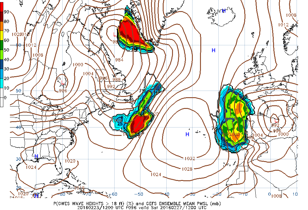
Likelihood of exceedance example image
10th percentile
The 10th percentile is the wave height value that is represented by 10% of the contributing ensemble members. For instance, there is a 10% probability of wave heights having a value equal or less than the given value. In the 96 hour forecast example shown below, the yellow zone of high waves west of Greenland in David Strait is 21 to 24 feet. The yellow reflects a range to 24 feet. The dark green area with the 18 black contours southwest of Nova Scotia has a yellow dot representing 21 ft. In both examples the 21 to 24 and 21 feet are representative of 10% of the members are less than those values.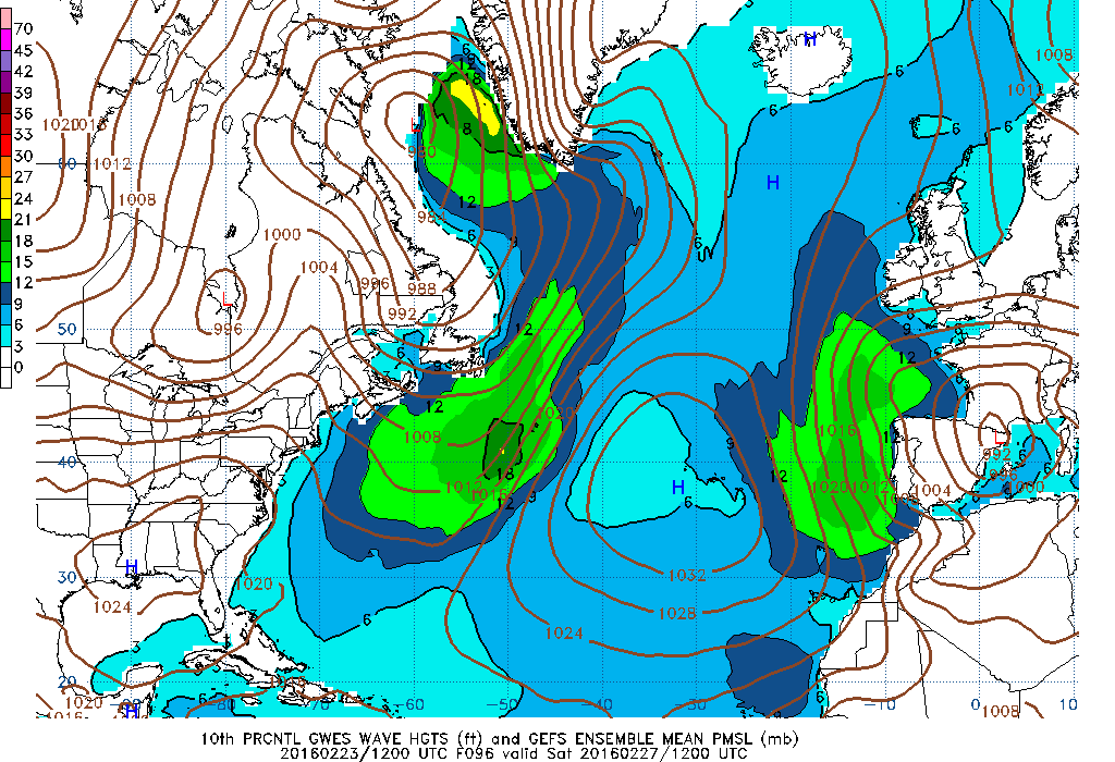
10th percentile example image
90th percentile
The 90th percentile represents the wave height value that 90% of the ensemble members are either less than or equal to (i.e., 18 feet). Looking at the same areas west of Greenland and southeast of Nova Scotia, 90% of the values are less than or equal to 33 feet and 24 feet, respectively.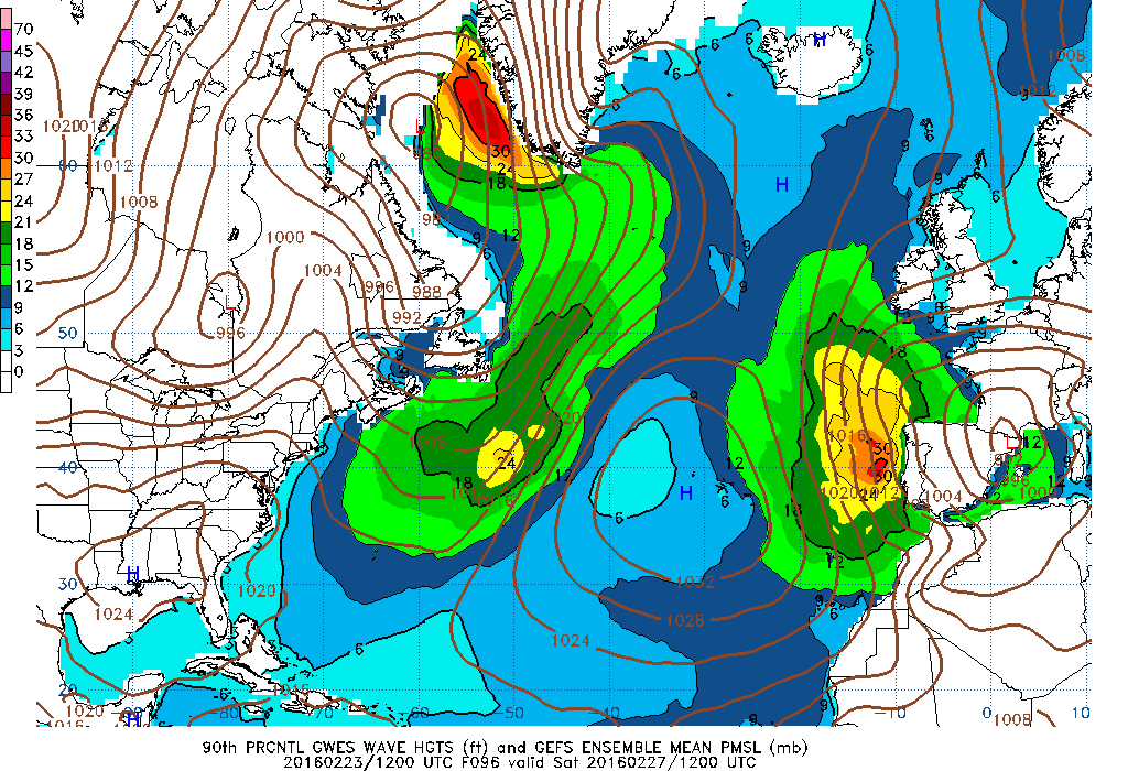
90th percentile example image
Mean
The mean is defined as the 50th percentile, that is, the wave height value represented reflects that half the distribution is above and half is below this value. In the example shown below the mean values are about 28 feet and 23 feet.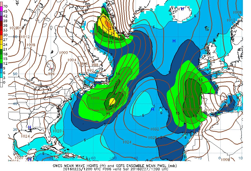
Mean example image
Maximum value
The maximum value is the highest value produced by any of the 21 ensemble members. It reflects the most severe conditions predicted by the ensemble prediction system. Following this example, the worst case scenario from the ensembles are maxima of 36 to 39 feet west of Greenland, and 25 feet southeast of Nova Scotia. As the ensemble forecasts proceed further in time and the contributing members begin to spread many individual maxima will appear.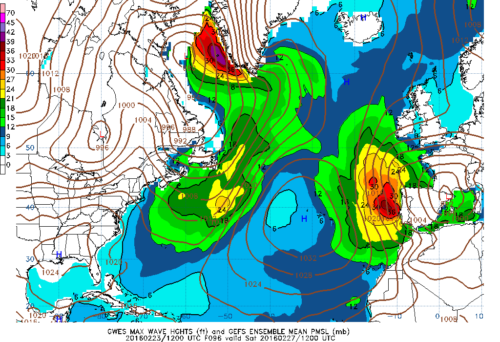
Maximum value example image
Comments or Questions
Return to main GWES Probabilistic Guidance Page