


| Hurricane Warnings in Effect | Pacific: High Seas EP1 and EPI |
Terminology and Weather Symbols
Graphical Products Legend

Standard Text Abbreviations
DCRSG = Decreasing
DVLPG = Developing
DSIPT = Dissipate
DSIPTG = Dissipating
FRZG SPRY = Freezing Spray
G = Gusts
HURCN = Hurricane
INCRSG = Increasing
ITCZ = Intertropical Convergence Zone
KT = Knots
MB = Millibars
MONSOON TROF = Monsoon Trough
MOVG = Moving
OUTFLOW BNDRY = Outflow Boundary
PRES = Pressure
Q-STNRY = Quasi-Stationary or Near Stationary
RPDLY INTSFYG = Rapidly Intensifying
STNRY = Stationary
STYPH = Super Typhoon
TRPCL STORM (TS) = Tropical Storm
TRPCL WAVE = Tropical Wave
TROF = Trough
WKNG = Weakening
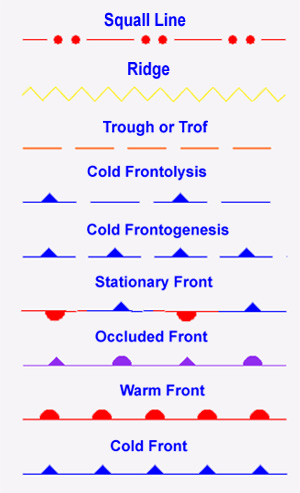
Fronts
-
-
Cold Front
The leading edge of a relatively colder air mass which separates two air masses in which the gradients of temperature and moisture are maximized. In the northern hemisphere winds ahead of the front will be southwest and shift into the northwest with frontal passage.
-
Frontogenesis
The formation of a front occurs when two adjacent air masses with different densities and temperatures meet and strengthen the discontinuity between the air masses. It occurs most frequently over continental land areas such as over the Eastern US when the air mass moves out over the ocean. It is the opposite of frontolysis.
-
Frontolysis
The weakening or dissipation of a front occurs when two adjacent air masses lose contrasting properties such as the density and temperature. It is the opposite of frontogenesis.
-
Occluded Front
The union of two fronts, formed as a cold front overtakes a warm front or quasi-stationary front refers to a cold front occlusion. When a warm front overtakes a cold front or quasi-stationary front the process is termed a warm front occlusion. These processes lead to the dissipation of the front in which there is no gradient in temperature and moisture.
-
Ridge
An elongated area of relatively high pressure that is typically associated with a anti-cyclonic wind shift.
-
Stationary Front
A front that has not moved appreciably from its previous analyzed position.
-
Trough (Trof)
An elongated area of relatively low pressure that is typically associated with a cyclonic wind shift.
-
Warm Front
The leading edge of a relatively warmer surface air mass which separates two distinctly different air masses. The gradients of temperature and moisture are maximized in the frontal zone. Ahead of a typical warm front in the northern hemisphere, winds are from the southeast and behind the front winds will shift to the southwest.
Low & High Pressure Systems and Miscellaneous Key Terms
-
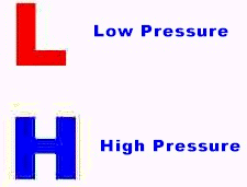
Low pressure with a number such as 99 means 999 mb and with 03 means 1003 mb.
High pressure with a number such as 25 means 1025 mb.
-
Extratropical Low
A low pressure center which refers to a migratory frontal cyclone of center and higher latitudes. Tropical cyclones occasionally evolve into extratropical lows losing tropical characteristics and become associated with frontal discontinuity.
-
Low Pressure
An area of low pressure identified with counterclockwise circulation in the northern hemisphere and clockwise in the southern hemisphere. Also, defined as a cyclone.
-
High Pressure
An area of higher pressure identified with a clockwise circulation in the northern hemisphere and a counterclockwise circulation in the southern hemisphere. Also, defined as an anticyclone.
-
New
The term "NEW" may be used in lieu of a forecast track position of a low pressure center when the center is expected to form by a specific time. For example, a surface analysis may depict a 24-hour position of a new low pressure center with an "X" at the 24-hour position followed by the term "NEW", the date and time in UTC which indicates the low is expected to form by 24 hours.
-
Rapidly intensifying
Indicates an expected rapid intensification of a cyclone with surface pressure expected to fall by at least 24 millibars (mb) within 24 hours.
-
Squall
A sudden wind increase characterized by a duration of minutes and followed by a sudden decrease in winds.
Station Plots
-
Decoding Station Plots

Weather Parameter Weather Symbol Weather Symbol Decoded Station ID KPZH Ship identifier Temperature (fahrenheit or celsius) 70 70 degrees fahrenheit Present weather 
Thunderstorm (additional present weather symobls) Dew point temperature (fahrenheit or celsius) 68 68 degrees fahrenheit Wind speed, direction, sky cover 
South-Southwest at 25 kt, overcast Station Pressure (mb) 048 1004.8 mb 3 hour pressure tendency -7 \ -0.7 mb pressure decrease with steady pressure fall optional wave height (feet or meter) 11 11 feet Sea Surface Temperature (fahrenheit or celsius) 75 75 degrees fahrenheit
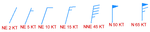
Wind Speed and Direction
-
-
Half Feathers = 5 knots
-
Full Feathers = 10 knots
-
Flags = 50 knots
-
Direction: Wind barbs point in the direction the wind is coming from.
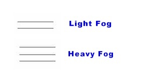
Fog
-
-
Fog
Over the marine environment the term fog refers to visibility greater than or equal to 1/2 NM and less than 3 NM. Fog is the visible aggregate of minute water droplets suspended in the atmosphere near the surface.
-
Dense Fog
Over the marine environment the term dense fog refers to visibility less than 1/2 NM. Fog is the visible aggregate of minute water droplets suspended in the atmosphere near the surface. Usually dense fog occurs when air that is lying over a warmer surface such as the Gulf Stream is advected across a colder water surface and the lower layer of the air mass is cooled below its dew point.
-
Sea Fog
Common advection fog caused by transport of moist air over a cold body of water.
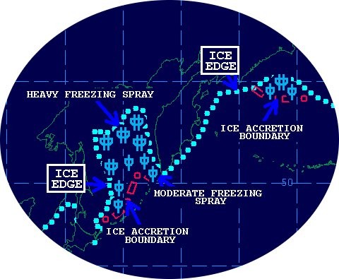
Freezing Spray and Ice Edge
-
-
Freezing Spray
Spray in which supercooled water droplets freeze upon contact with exposed objects below the freezing point of water. It usually develops in areas with winds of at least 25 knots.
-
Categories of Freezing Spray/Icing

Light Moderate Heavy Less than 0.7 cm/hr 0.7 cm/hr to less than 2.0 cm/hr Greater than or equal to 2.0 cm/hr Less than 0.3 in/hr 0.3 in/hr to less than 0.8 in/hr Greater than or equal to 0.8 in/hr -
Ice Edge
Represented by a blue dotted line and is defined by the U.S. National Ice Center. It depicts the extent of ice coverage 10% or greater.
Conventions Used With Warnings for Extratropical Systems
-
Complex Gale/Storm
An area in which gale/storm force winds are forecast or are occurring, but in which more than one center is the generating these winds.
-
Developing Gale
Refers to an extratropical low or an area in which gale force winds of 34 knots (39 mph) to 47 knots (54 mph) are expected by a certain time period. On surface analysis charts, a "DEVELOPING GALE" label indicates gale force winds within the next 24 hours. When the label is used on the 48, 72, or 96 hour surface forecast charts, gale force winds are expected to develop by 72, 96, or 120 hours, respectively.
-
Developing Storm
Refers to an extratropical low or an area in which storm force winds of 48 knots (55 mph) to 63 knots (73 mph) are expected by a certain time period. On surface analysis charts, a "DEVELOPING STORM" label indicates storm force winds forecast within the next 24 hours. When the label is used on the 48, 72, or 96 hour surface charts, storm force winds are expected to develop by 72, 96, or 120 hours, respectively.
-
Developing Hurricane Force
Refers to an extratropical low or an area in which hurricane force winds of 64 knots (74 mph) or greater are expected by a certain time period. On surface analysis charts, a "DEVELOPING HURRICANE FORCE" label indicates huricane force winds forecast within the next 24 hours. When the label is used on the 48, 72 or 96 hour surface charts, hurricane force winds are expected to develop by 72, 96, or 120 hours, respectively.
-
Gale
Refers to an extratropical low or an area of sustained surface winds (averaged over a ten minute period, momentary gusts may be higher) of 34 knots (39 mph) to 47 knots (54 mph).
-
Storm
Refers to a extratropical low or an area of sustained winds (averaged over a ten minute period, momentary gusts may be higher) of 48 knots (55 mph) to 63 knots (73 mph).
-
Hurricane Force
Refers to a extratropical low or an area of sustained winds (averaged over a ten minute period, momentary gusts may be higher) in excess of 64 knots or higher(74 mph).
-
Small Craft Advisory
Refers to areas within the coastal waters with sustained winds of 18 knots (21 mph) to 33 knots (38 mph).
-
Heavy Freezing Spray
Spray in which supercooled water droplets freeze upon contact with exposed objects below the freezing point of water at the rate of greater than or equal to 2 cm/hr. It usually develops in areas with winds of at least 25 knots.
Conventions Used With Warnings for Tropcial Systems
-

-
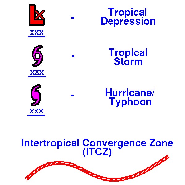
Hurricane
A tropical cyclone with closed contours, a strong and very pronounced circulation, and one minute maximum sustained surface winds 64 knots (74 mph) or greater. A system is called a hurricane over the North Atlantic, Gulf of America, North Pacific E of the dateline, and the South Pacific E of 160E.
-
Intertropical Convergence Zone (ITZC)
The region where the northeasterly and southeasterly trade winds converge, forming an often continuous band of clouds or thunderstorms near the equator.
-
Monsoon Trough
An elongated area of low pressure along the Intertropical Convergence Zone (ITCZ) that leads to an enhancement of monsoon precipitation over land. Winds are typically southwesterly to its south. Monsoon troughs can lead to tropical development, particularly in the Northwest Pacific.
-
Post-Tropical
A cyclone that no longer possesses sufficient tropical characteristics to be considered a tropical cyclone. Post-tropical cyclones can continue carrying intense rainfalls and high winds. [Note that former tropical cyclones that have become fully extra-tropical, as well as remnant lows, are two classes of post-tropical cyclones. The term "post-tropical" is predominantly a convenient communications term--to permit the ongoing use of the storm name.]
-
Tropical Cyclone
A non-frontal, warm-core, low pressure system of synoptic scale, developing over tropical or subtropical waters with definite organized convection (thunderstorms) and a well defined surface wind circulation.
-
Tropical Depression
A tropical cyclone with one or more closed isobars and a one minute max sustained surface wind of less than 34 knots (39 mph).
-
Tropical Storm
A tropical cyclone with closed isobars and a one minute max sustained surface wind of 34 knots (39 mph) to 63 knots (73 mph).
-
Tropical Wave
A trough in the trade-wind easterlies.
-
Typhoon
Same as a hurricane with exception of geographical area. A tropical cyclone with closed contours, a strong and very pronounced circulation, and one minute maximum sustained surface winds of 64 knots (74 mph) or greater. A system is defined as a typhoon over the North Pacific W of the dateline.
Super Typhoons are typhoons with sustained winds of 130 knows (150 mph) or greater.
-
Note: It can be difficult to determine the central pressures of tropical depressions, tropical storms, and hurricanes/typhoons and at times no estimates or measurements is provided by a hurricane or typhoon specialist. An estimate of central pressure may be provided over the Atlantic. Otherwise an "XXX" is used in place of actual or estimated pressures associated with these systems and an XX is used for forecast central pressure.
Seas
-
Combined Seas
The combination of both wind waves and swell which is generally referred to as "seas".
-
Primary Swell Direction
Prevailing direction of swell propagation.
-
Significant Wave Height
The average height (trough to crest) of the 1/3rd highest waves. An experienced observer will most frequently report the highest 1/3rd of the waves observed.
The generation of waves on water results not in a single wave height but in a spectrum of waves distributed from the smallest capillary waves to larger waves. Within this spectrum there is a finite possibility of each of the wave heights to occur with the largest waves being the least likely. The wave height most commonly observed and forecast is the significant wave height. This is defined as the average of the one third highest waves. The random nature of waves implies that individual waves can be substantially higher than the significant wave height. In fact, observations and theory show that the highest individual waves in a typical storm with typical duration to be approximately two times the significant wave height. Some reported rogue waves are well within this factor of two envelope. Waves higher than roughly twice the significant wave height fall into the category of extreme or rogue waves.
-
Swell
Wind waves that have moved out of their fetch or wind generation area. Waves generated by swell exhibit a regular and longer period than wind waves.
Miscellaneous Terminology
-
Coastal Waters
Includes the area from a line approximating the mean high water along the mainland or island as far out as sixty nautical miles including the bays, harbors and sounds.
-
Offshore Waters
That portion of oceans, gulfs, and seas beyond coastal waters extending to a specified distance from the coastline, to a specified depth contour, or covering an area defined by a specific latitude and longitude points.
-
High Seas
That portion of the Atlantic and Pacific oceans which extends off the Western and Eastern US coasts and extends to 35W in the Atlantic ocean and to 180W in the Pacific Ocean. The area includes both the coastal and offshore waters.